Camino Portugués: two ways out of Porto, one road to Santiago
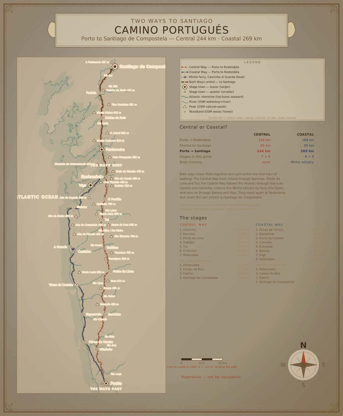
The Portuguese Way is the second-most walked route to Santiago — and the one that makes you choose. From Porto the Caminho Central heads inland and the Caminho da Costa follows the Atlantic; both reach Redondela, and from there a single shared route runs north to Santiago de Compostela. WalkSage covers all three legs, with the quiet places each way is known for.
How these guides are different
Each stage guide lists the towns you'll pass, the points of interest worth a detour, and a Local Angle for each — the quieter hour, the better path, the detail the guidebooks skip. Every factual claim carries cited sources, and anything we haven't verified is labelled honestly: distances we can't confirm say "see stage map", not a guessed number. Overcrowded staples are deliberately left out.
Stages
19 of 19 planned stage guides published so far. More publish as they clear verification.
Leaving Porto you have to choose. The Caminho Central turns inland and takes the historic line north through Barcelos, Ponte de Lima and Tui; the Caminho da Costa keeps the Atlantic on its left through Viana do Castelo and Caminha, crossing the Minho into Spain by ferry. Neither is a detour from the other — they are two full routes. They meet at Redondela, and from there every pilgrim walks the same stages to Santiago.
Central Way — Caminho Central
Inland through Barcelos, Ponte de Lima and Tui: Roman roads, medieval bridges and the densest waymarking of the two.
- STAGE 1Porto → Vilarinho≈ 26 km
- STAGE 2Vilarinho → Barcelos≈ 27 km
- STAGE 3Barcelos → Ponte de Lima≈ 34 km
- STAGE 4Ponte de Lima → Rubiães≈ 18 km
- STAGE 5Rubiães → Tui≈ 20.5 km
- STAGE 6Tui → O Porriño≈ 17.5 km
- STAGE 7O Porriño → Redondela≈ 16 km
Coastal Way — Caminho da Costa
North along the Atlantic through Viana do Castelo, Caminha, Baiona and Vigo — including a ferry crossing of the Minho into Spain.
- STAGE 1Porto → Póvoa de Varzim≈ 31 km
- STAGE 2Póvoa de Varzim → Esposende≈ 21 km
- STAGE 3Esposende → Viana do Castelo≈ 26 km
- STAGE 4Viana do Castelo → Caminha≈ 27.5 km
- STAGE 5Caminha → A Guarda≈ 5.5 km
- STAGE 6A Guarda → Baiona≈ 32 km
- STAGE 7Baiona → Vigo≈ 26.5 km
- STAGE 8Vigo → Redondela≈ 14.5 km
Both Ways: Redondela → Santiago
The stages after the two ways merge — walked by every pilgrim, whichever way they came out of Porto.
Everyone walks these. Whichever way you chose, the route from Redondela onward is the same — these guides apply to both.
- STAGE 1Redondela → Pontevedra≈ 20.5 km
- STAGE 2Pontevedra → Caldas de Reis≈ 21 km
- STAGE 3Caldas de Reis → Padrón≈ 19 km
- STAGE 4Padrón → Santiago de Compostela≈ 25 km
Town & planning guides
- TOWNBaiona Beyond the Crowds: Exploring the Town's Rich Heritage
- TOWNBarcelos Beyond the Crowds: A Pilgrim's Guide to Cultural Heritage
- PLANNINGThe Best Time to Walk the Camino Portugués
- TOWNCaminha Beyond the Crowds: Discovering the Town's Rich Heritage
- PLANNINGCamino Portugués: Central or Coastal? What the Data Says About Choosing
- PLANNINGCamino Portugués Crowd Index: Every Town on Both Routes, Ranked
- PLANNINGCamino Portugués Distance: Central vs Coastal Route
- PLANNINGWalking the Camino Portugués from Porto: Understanding the Route
- PLANNINGConverging Paths: Redondela and the Road to Santiago
- PLANNINGCamino Portugués vs Camino Francés: Choosing Your Path
- TOWNEsposende Beyond the Crowds: Exploring the Town's Lesser-Known Heritage
- TOWNPadrón Beyond the Crowds: Exploring the Town's Lesser-Known Heritage
- TOWNPonte de Lima Beyond the Crowds: Exploring the Town's Cultural Heritage
- TOWNPontevedra Beyond the Crowds: Exploring the City's Less Visited Gems
- TOWNPorto Beyond the Crowds: Exploring the City's Rich History and Culture
- TOWNPóvoa de Varzim Beyond the Crowds
- PLANNINGThe Quietest Way to Walk the Camino Portugués
- TOWNTui Beyond the Crowds: Exploring the Less Visited
- TOWNViana do Castelo Beyond the Crowds: Exploring Heritage Sites
- TOWNVigo Beyond the Crowds: Exploring the City's Lesser-Known Gems